Welcome!

Benvenuti in queste pagine dedicate all'archeologia. Amelia Carolina Sparavigna

Wednesday, 22 June 2011

Padmapani


Padmapani
Gandhara, II-III secolo d.C.

Il Bodhisattva Padmapani siede su un alto trono con il piede sinistro posato a terra e la gamba destra piegata a appoggiata sul ginocchio opposto. L’alto seggio su cui Padmapani รจ seduto ha una spessa base su cui si appoggiano i sandali (infradito!). Il Bodhisattva indossa paridhana e uttariya. Porta un turbante a fascia, grandi orecchini a testa di leone, collane e un cordone con piccoli involucri porta-preghiere, portato di traverso dalla spalla sinistra al fianco destro. Padmapani tiene nella mano sinistra un grosso bocciolo di fiore di loto, mentre l’altra, mancante, era rivolta verso la testa.

Museo Arte Orientale, Torino

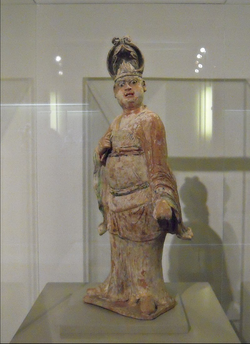
Il funzionario militare


Funzionario militare
Dinastia Tang, VIII secolo D.C.
Terracotta rossa, ingobbio bianco, pigmenti e oro
Military official
Tang Dinasty 8th centry A.D.
Red earthenware with white engobe, pigments and gold


Museo Arte Orientale, Torino

Geoglyphs in Bolivia


The image shows the "raised fields" near the Titicaca Lake, in Bolivia.
Note the "snake": eye, tongue and teeth. 

This image, obtained after processing a Google Maps image, shows the network of waru-warus, that is, of the "raised fields" - earthworks separated by canals - near Tiwanaku. This is an ancient agricultural technique used by Andean people starting from the first millennium BC. Each raised field is approximately 10 meters large and more than one hundred long. 

More on waru-waru


 arXiv:1009.4602 [pdfGeoglyphs of Titicaca as an ancient example of graphic design, Amelia Carolina Sparavigna


 arXiv:1009.2231 [pdfSymbolic landforms created by ancient earthworks near Lake Titicaca, Amelia Carolina Sparavigna

Andenes in peru


Andenes are an ancient method to cultivate the Andean highlands.
Here an image from Google Maps.

Ringed hills

A beautiful collection of images from Google Maps.
http://www.atlantisbolivia.org/ringedhills.htm
Very interesting the top of the hill with concentric rings!
"Many of the hilltops on the Bolivian altiplano have at some time been surrounded by concentric ringed walls and/or irrigation channels and many of these hilltops in turn seem to have suffered from earthquake damage. Closer study suggests that many hilltops originally had concentric ringed irrigation canals, but in many zones these appear to have been destroyed by earthquakes and later generations have reoccupied the land and built walls alongside the former irrigation ditches."
I have searched the "ringed feature south of volcan Quemado". Here it is after processing.


Another ringed structure

Images obtained by Google Maps

Alpaca

In the "The Continuum encyclopedia of animal symbolism in art", by Hope B. Werness, we can find a very interesting discussion on Alpaca.

Waru-warus


This image, obtained after processing a Google Maps image, shows the network of waru-warus, that is, of the "raised fields" - earthworks separated by canals - near the Titicaca Lake (Huata, Puno, Peru). This is an ancient agricultural technique used by Andean people starting from the first millennium BC. Note that the structure of the network is created after a careful planning. 
Each raised field is approximately 10 meters large and more than one hundred long. 

More on waru-warus
arXiv:1009.4602 [pdf] Geoglyphs of Titicaca as an ancient example of graphic design, Amelia Carolina Sparavigna
arXiv:1009.2231 [pdf] Symbolic landforms created by ancient earthworks near Lake Titicaca, Amelia Carolina Sparavigna

Radial structures at Rodadero

As discussed in some previous posts on "qochas", these structures had and have an agricultural function. Some qochas had a ceremonial use too. At Rodadero (Cusco) we find the huge Qocha Chincanas.
Near the parking of this archaeological site, where it is placed the statue of the White Christ, the satellite imagery (Google Maps) shows two radial/circular structures as those used for agricultural purposed near Titicaca lake.


Near Qenko and Rodadero

One of the beautiful examples of the Incaic culture in the Cusco region are the ruins of Qenko, located  approximately 6 kilometers  from the capital of the area, Cusco. Qenko is near the Rodadero, a giant rock hill with numerous stairwells and benches carved into the stone. The hills near  Qenko and Rodadero are used as cropfields. During this weekend I was studying qochas (lakes, ponds) and searching for ceremonial qochas in Peru, when I saw by means of Google Maps this hill. After image processing to enhance details, it seems that this hill possesses many concentric structures, as a qocha. May be it is another ceremonial qochas near Cusco.

Geoglyphs of Titicaca

Geoglyphs of Titicaca


28 p. Book Geoglyphs Titicaca Sparavigna

Images of geoglyphs near Titicaca Lake. The ancient artificial landscape
 with geoglyphs is an important example of an engineering graphic design
 for an age and place where no written documents existed. Geoglyphs 
are created by a network of earthworks, which constitute the remains
of an extensive ancient agricultural system. It can be seen by means 
of the Google satellite imagery on the Peruvian region near the Titicaca Lake.
Public Category: Research Reads: 2657 Published: 10 / 09 / 2010 Share Add to Collections

Landforms of Titicaca: Near Sillustani

18 p. Landforms of Titicaca: Near Sillustani, Book by A.C. Sparavigna

Terraced hills, a network of earthworks, sometimes creating geoglyphs,
 and ancient ruins are the structures we can observe with the satellites 
imagery of Google Maps. After the previous publications on the
 earthworks and geoglyphs , let us survey specific area with more
 details. Here we show satellite imagery, enhanced with freely 
available image processing software, of the area near Sillustani,
 the peninsula of the Laguna Umayo, in Puno region of Peru. 
Besides Sillustani, interesting places are the 
Mesa Isla and Atuncalla.
Public Category: Research Reads: 286 Published: 10 / 27 / 2010

Landforms of Titicaca: Amazing Land

18 p. Landforms Titicaca Amazing Land by AC Sparavigna

The areas of Huata, Coata and Paucarcolla, near the Titicaca Lake,
 are covered by amazing drawings. For these regions, Google Maps
 has enough high resolution to have a detailed survey.
In the book, the reader can see a show of images obtained
by enhancing the satellite imagery.
 Each image has coordinates and scale.

Public Category: Research Reads: 207 Published: 10 / 28 / 2010
  Share Add to Collections

A snake

Image from Google Maps after processing to enhance details.
Near the Titicaca Lake, Peru.

This image shows a small area covered by a network of waru-warus, that is, of the "raised fields" - earthworks separated by canals - near the Titicaca Lake. This is an ancient agricultural technique used by Andean people starting from the first millennium BC. Note that the structure of the network is created after a careful planning. Each raised field is approximately 10 meters large and more than one hundred long. 

It seems a snake, the pond as its eye and a bifid tongue.
To see the forked tongue it is necessary a zoom on the head and a filtering with wavelets to enhance the details.


More on waru-waru
arXiv:1009.4602 [pdf] Geoglyphs of Titicaca as an ancient example of graphic design,
arXiv:1009.2231 [pdf] Symbolic landforms created by ancient earthworks near Lake Titicaca,

"Around the World" in ancient agriculture

There is a beautiful book by ร‰ric Mollard, Annie Walter, ร‰diteurs scientifiques. The title is "Agricultures singuliรจres", IRD ร‰ditions, Institut de recherche pour le dรฉveloppement, Paris, 2008. 
It is an "around the world" in ancient agricultural techniques.
Let me report a small part of this book.

Les qochas de l’Altiplano
En langue quechua, le terme qocha dรฉsigne les lacs, les cuvettes, les รฉtangs et, de faรงongรฉnรฉrale, tout bassin inondรฉ artificiel ou naturel, toute dรฉpression ร  la surface du sol. C’est รฉgalement le nom donnรฉ ร  un type d’assiette cรฉrรฉmonielle en cรฉramique. Les qochas (ou cochas suivant les graphies) sont des cuvettes naturelles ou creusรฉes par les hommes, reliรฉes entre elles pour former un vรฉritable systรจme hydraulique. Le terme
dรฉsigne ร  la fois un unique bassin et le systรจme dans son ensemble. Les terrains qui les sรฉparent ne sont pas cultivรฉs mais dรฉdiรฉs ร  l’รฉlevage. Les qochas sont l’un des nombreux systรจmes de gestion des eaux et du sol qui ont permis aux anciennes populations andines de cultiver la terre et de survivre. On trouve les qochas dans de rares rรฉgions des Altiplanos pรฉruvien et bolivien, ร  une altitude moyenne de 4 000 mรจtres. Ils sont trรจs nombreux et denses dans le dรฉpartement de Puno (Pรฉrou) oรน ils ont รฉtรฉ dรฉcouverts et bien documentรฉs...


Les  qochas sont des dรฉpressions, amรฉnagรฉes par les hommes selon trois formes de base. Les plus frรฉquentes sont rondes et mesurent de 30 mรจtres ร  200 mรจtres de diamรจtre pour une superficie moyenne de 6 000 m2. ...La qocha sert alternativement de champ de culture, de pรขturage et de rรฉservoir d’eau. ... On y cultive avant tout la pomme de terre ainsi que la caรฑihua (Chenopodium pallidicaule) et la quinoa (Chenopodium quinoa), l’avoine, l’orge et le blรฉparfois en rotation. La qocha supporte des cultures de pomme de terre la premiรจre annรฉe, de quinoa la deuxiรจme annรฉe, d’avoine et d’orge la troisiรจme annรฉe puis suit une jachรจre pรขturรฉe de durรฉe variable. La taille d’une qocha est gรฉnรฉralement exprimรฉe en masa, c’est-ร -dire en surface labourรฉe en un jour par une รฉquipe constituรฉe de deux hommes et d’une femme. Le rendement est d’environ une tonne par masa. Le systรจme permet une rรฉgulation souple de l’eau de pluie dans une rรฉgion qui doit faire face ร  une succession de fortes sรฉcheresses suivies d’inondations....
Le systรจme des qochas est sans doute l’agriculture de l’Altiplano, autour du lac Titicaca, la moins รฉtudiรฉe si bien qu’il existe peu de rรฉfรฉrences ร  son sujet. Cela s’explique en partie par le fait qu’au XVI e siรจcle, elles รฉtaient situรฉes en dehors des voies de passage principales. Plus tard, les lignes de chemin de fer ont traversรฉ ces larges dรฉpressions peu profondes, sans que les voyageurs puissent les remarquer, au premier coup d’ล“il. Ce n’est qu’en 1962 qu’elles ont รฉtรฉ mentionnรฉes pour la premiรจre fois, par des รฉtudiants en archรฉologie qui travaillaient dans le Puno, alors mรชme que beaucoup d’entre elles รฉtaient encore en activitรฉ. Elles sont d’origine prรฉincaรฏque comme en tรฉmoignent les tessons dรฉcouverts ร  proximitรฉ. Bien que le systรจme soit vraisemblablement antรฉrieur, il est associรฉ au site Pukara.
Pukara a รฉtรฉ un centre de peuplement important durant des centaines d’annรฉes depuis 1 300 avant  J.-C. puis il est devenu, entre 250 avant J.-C. et 380 aprรจs J.-C., un important site religieux, densรฉment peuplรฉ. Une sociรฉtรฉ fortement hiรฉrarchisรฉe y tenait de grandes cรฉrรฉmonies et a รฉtรฉ capable d’assurer une gestion centralisรฉe de l’eau. Mais certains auteurs suggรจrent que l’amรฉnagement et la maintenance des structures agricoles, dont les qochas, ont รฉtรฉ tout aussi bien mis en ล“uvre par des groupements communautaires locaux. Mรชme en supposant que les paysans aient utilisรฉ des 
dรฉpressions existantes dans lesquelles l’eau de pluie s’accumulait, il est certain qu’une grande maind’ล“uvre et une longue pรฉriode de temps ont รฉtรฉ nรฉcessaires pour amรฉnager ce systรจme complexe sur une grande รฉtendue. Outre les qochas, cette civilisation a aussi construit d’importants ensembles de champs surรฉlevรฉs (ERICKSON, 1994). Puis, le site a รฉtรฉ progressivement abandonnรฉ avec la montรฉe en puissance de Tihuanacu avec laquelle Pukara a entretenu des liens commerciaux et sociaux. Cette civilisation andine qui a รฉtendu son influence jusqu’au nord du Chili, a pratiquรฉ une agriculture fondรฉe sur la construction des terrasses (andenes), des champs surรฉlevรฉs (camellones) et aussi quelques  qochas. Mais elles sont peu dรฉveloppรฉes dans la vallรฉe de Tihuanacu, sans doute parce que leur capacitรฉ de production est insuffisante pour une nombreuse population. Aprรจs la chute de Tihuanacu, en l’an 1000, le site de Pukara a รฉtรฉ de nouveau occupรฉ et les qochas utilisรฉes. La rรฉgion a traversรฉ ร  
cette รฉpoque une longue pรฉriode de sรฉcheresse qui a pu rendre l’utilisation des qochas indispensable pour la survie des populations locales. Plus tard, les Huari puis les Incas ont dรฉveloppรฉ des systรจmes renommรฉs de terrasses mais les qochas ont continuรฉ ร  รชtre cultivรฉes, en complรฉment de  l’agriculture de pente. La conquรชte espagnole a par la suite entraรฎnรฉ une grave dรฉpopulation locale qui a conduit ร  l’abandon partiel de toutes les structures agricoles mais les  qochas, toujours utilisรฉes par quelques groupes, ont rรฉussi ร  traverser les siรจcles, les guerres et la colonisation. Elles apparaissent donc comme des structures complรฉmentaires ร  celles qui soutiennent l’agriculture principale et se dรฉveloppent quand les conditions environnementales (naturelles ou sociales) fragilisent l’agriculture et les communautรฉs locales.
Aujourd’hui, des secteurs entiers de  qochas ont รฉtรฉ abandonnรฉs ou dรฉtรฉriorรฉs soit pour des raisons de salinitรฉ des sols, soit ร  cause d’une mรฉcanisation imprudente dans les secteurs d’haciendas. Mais elles occupent encore plus de 250 km2, avec une densitรฉ d’environ 100 qochas au kilomรจtre carrรฉ. Au total, plus de 20 000 cuvettes sont actuellement utilisรฉes de faรงon intensive par les populations andines 
contemporaines. Elles ne sont pas les seules structures agricoles de la rรฉgion et les communautรฉs locales cultivent aussi les pentes, amรฉnagรฉes en terrasses (andenes) et construisent des  camellones (ici appelรฉs waru-waru).

Earthworks near Titicaca


Earthworks near Titicaca Lake
These earthworks are known as "raised fields" and "waru-warus".

The image, obtained from Google Maps, shows the network of earthworks separated by canals - near the Titicaca Lake (Huata, Puno, Peru). This is an ancient agricultural technique used by Andean people starting from the first millennium BC. Note that the structure of the network is created after a careful planning. Each raised field is approximately 10 meters large and more than one hundred long. 

Let us rotate a part of the image and enhance it.


A "hand"?


More on waru-waru
 arXiv:1009.4602 [pdfGeoglyphs of Titicaca as an ancient example of graphic design,
 arXiv:1009.2231 [pdfSymbolic landforms created by ancient earthworks near Lake Titicaca, Amelia Carolina Sparavigna