"Before the coming of white settlers, the region surrounding Jefferson City was home to an ancient group known as the Mound People. In fact, America's largest prehistoric city was located only 160 miles away at what is now Cahokia, Illinois. Why this civilization disappeared remains a mystery."
http://www.jeffcitymo.org/main/historyheritage.html
Information on the mounds near Jefferson City we can find in the paper
published by The Project Gutenberg EBook of Scientific American Supplement, No. 841,
February 13, 1892, by Various
INVESTIGATION OF A MOUND NEAR JEFFERSON CITY, MO, By A.S. LOGAN.
Logan wrote
"Recently, a party consisting of engineers and employes of the Missouri River Improvement Commission began an exploration of one of the mounds, a work of a prehistoric race, situated on the bluff, which overlooks the Missouri River from an elevation of one hundred and fifty feet, located about six miles below Jefferson City.
This mound is one of about twenty embraced in a circle one quarter of a mile in diameter.
The above party selected the mound in question apparently at haphazard; all the mounds presenting nearly a uniform outline, differing only in size and mostly circular in form, and from twenty to twenty-four feet at the base, rising to a height of eight feet and under. A trench was cut on a level with the natural soil, penetrating the mound about eight feet. A stone wall was encountered which was built very substantially, making access in that direction difficult, in consequence of which the earth was removed from the top for the purpose of entering from that direction. The earth was removed for a depth of four feet, when the top of the wall was exposed. Further excavation brought to light human bones, some of them fairly well preserved, especially the bones of the legs. On the removal of these and a layer of clay, another layer of bones was exposed, but presenting a different appearance than the first, having evidently been burned or charred, a considerable quantity of charcoal being mixed with the bones. In this tier were found portions of several skulls, lying close together, as if they had been interred without regard to order. They were, in all probability, detached from the body when buried....
A few pieces of flint weapons were found in the upper layers, and nothing else of any significance....
At this juncture the diggers abandoned the search, and some days later the writer, desirous of seeing all that was to be seen, resumed the work and removed the earth and remains until the bottom of the vault was reached; several layers being thus removed. All of these had evidently been burned, as charcoal and ashes were mixed with the bones of each succeeding layer. The layers were about an inch in thickness, with from two to four inches of earth between, and small flat stones, about the size of a man's hand, spread on each different layer, as if to mark its division from the next above.
Between the bottom layers, mixed with charcoal, ashes and small portions of burned bones were found what gives value to the search, numbering about fifty tools and a smoking pipe.
The material of the tools is the same as the rock forming the vault, locally known as "cotton rock." I would consider it a species of sandstone.
Overlying the edge of "cotton rock" in the bluff is flint in great quantities, and in every conceivable shape, that these people could have resorted to had they been so disposed, and why they used the softer material I will leave to some archæologist to determine. The tools themselves are made after no pattern, but selected for their cutting qualities, as they all have a more or less keen edge which could be used for cutting purposes, and were no doubt highly prized, as they were found all in a pile in one corner of the vault and on top of which was found a stone pipe. The pipe is made bowl and stem together, and it is curious that people of such crude ideas of tools and weapons should manufacture such a perfect specimen of a pipe. It is composed of a very heavy stone, the nature of which would be difficult to determine, as it is considerably burned.
A description of the vault will be found interesting to many. The wall of the vault rests upon the natural surface of the ground, about three feet high and eight and a half feet square, the inside corners being slightly rounded; it is built in layers about four inches in thickness and varying in length upward to three feet, neither cement nor mortar being used in the joints; the corners formed a sort of recess as they were drawn inward to the top, in which many of the stones were found. The stone for constructing the vault was brought from a distance of about a quarter of a mile, as there is none in sight nearer.
I assume from all these circumstances that these people lived in this neighborhood anterior to the age of flint tools, as the more recent interments indicate that they were then entering upon the flint industry, and it may be that the "cotton rock" had become obsolete.
These people buried their dead on the highest ground, covering and protecting them with these great mounds, when it would seem much easier to bury as at the present day; but instead, they, with great labor, carried the rock from a great distance, and it is reasonable to suppose, also, that the earth was brought from a distance with which they are surrounded, and piled high above, as there is no trace of an immediate or local excavation....
My object is the hope of a more thorough investigation at some future time...."
Thursday, 29 December 2011
Monday, 5 December 2011
Hic sunt Garamantes
"Satellites and aerial photographs have revealed evidence of over a hundred fortified farms, villages, and towns - many with castle-like structures - in the southwestern deserts of Libya. These structures date back to between 1 and 500 C.E., meaning they predate the rise of Islam. ...
Archaeologists from the University of Leicester have used all this aerial data to identify as much as they can about the so-called Garamantes people, who are otherwise known purely through Greek and Roman sources. They've already discovered "the mud brick remains of the castle-like complexes, with walls still standing up to four metres high, along with traces of dwellings, cairn cemeteries, associated field systems, wells and sophisticated irrigation systems." "
http://io9.com/5857958/satellites-reveal-libyas-lost-2000+year+old-cities
Sunday, 20 November 2011

Tuesday, 15 November 2011
Leonardo, Genio e Mito
Alla Venaria Reale (Torino) si apre la mostra su Leonardo da Vinci. Il titolo è "Leonardo, il Genio, il Mito".
In esposizione vi è l'autoritratto della Biblioteca Reale e il Codice del Volo.
In una pagina del codice, sotto la scrittora di Leonardo, vi è un ritratto, forse un suo autoritratto da giovane.

Image processing della pagina del codice, A.C. Sparavigna

Friday, 14 October 2011
Mela, Pomponius
"Pomponius Mela, who wrote around AD 43, was the earliest Roman geographer. He was born in Tingentera (Algeciras) and died c 45 CE. His short work (De situ orbis libri III.) occupies less than one hundred pages of ordinary print. It is laconic in style and deficient in method, but of pure Latinity, and occasionally relieved by pleasing word-pictures. Excepting the geographical parts of Pliny's Historia naturalis (where Mela is cited as an important authority) the De situ orbis is the only formal treatise on the subject in Classical Latin."
http://en.wikipedia.org/wiki/Pomponius_Mela
http://en.wikipedia.org/wiki/Pomponius_Mela
Munich Digitization Center
Digitised works/ Author: Mela, Pomponius
http://www.digital-collections.de/index.html?c=autoren_index&l=en&ab=Mela%2C+Pomponius
Digitised works/ Author: Mela, Pomponius
http://www.digital-collections.de/index.html?c=autoren_index&l=en&ab=Mela%2C+Pomponius
Thursday, 13 October 2011
Indos
"Sed praeter physicos Homerumque qui universum orbem mari circumfusum esse dixerunt, Cornelius Nepos ut recentior, auctoritate sic certior; testem autem rei Quintum Metellum Celerem adicit, eumque ita rettulisse commemorat: cum Galliae pro consule praeesset, Indos quosdam a rege Botorum (Boiorum) dono sibi datos; unde in eas terras devenissent requirendo cognosse, vi tempestatium ex Indicis aequoribus abreptos, emensosque quae intererant, tandem in Germaniae litora exisse. Restat ergo pelagus, sed reliqua lateris eiusdem adsiduo gelu durantur et ideo deserta sunt."
Pomponius Mela
De chorographia
"Mais à l'autorité des anciens philosophes et d'Homère, qui ont prétendu que la terre était de tous côtés environnée par la mer, on peut ajouter celle de Cornélius Nepos, qui, étant plus moderne, est par conséquent plus sûr. Or, cet auteur rapporte, à l'appui de cette opinion , le témoignage de Q. Metellus Celer, auquel il fait dire qu'étant proconsul dans la Gaule, le roi des Bètes lui fit présent de quelques Indiens , et que, s'étant informé d'où ils étaient venus, il apprit que, les tempêtes les ayant emportés loin de la mer des Indes, ils avaient été jetés, après un long trajet, sur les rivages de la Germanie. Le reste de la côte asiatique est donc baigné au nord par une mer sans bornes; mais cette partie est couverte de glaces éternelles, et par conséquent déserte.
Louis Baudet translation
To the ancient philosophers and Homer, who claimed that the land was surrounded on all sides by the sea, we may add Cornelius Nepos, who, being more modern, is therefore more reliable. However, this author reports in supporting this fact, the witness of Q. Metellus Celer: when he was proconsul in Gaul, the king of Botos made him a present of a few Indians, and that, being informed of where they came from, he learned that the storms have swept away them of the Indian Ocean. They were thrown, after a long journey, on the shores of Germania. The rest of the northern Asian shores are surrounded by the sea, but this part is covered with eternal ice, and therefore deserted.
King Arthur's round table
According to Telegraph, http://www.telegraph.co.uk/news/uknews/8724183/King-Arthurs-round-table-may-have-been-found-by-archaeologists-in-Scotland.html, 26 Aug 2011, King Arthur's round table may have been found by archaeologists in Scotland. In fact, the archaeologists have found a "circular feature" beneath the historic King's Knot in Stirling. The King's Knot is a geometrical earthwork in the gardens below Stirling Castle. The design of the Knot that we see today dates from the 1620s, but its central mound could be much older. It seems that some writers going back more than six centuries have linked the landmark to King Arthur. Archaeologists from Glasgow University, working with the local Archaeological Society, found that the round feature on the site pre-dates the visible earthworks.

How to measure the stair angle
Use a protractor (available at most hardware stores) to determine this angle.

Lay a straightedge across a minimum of 3 stair nosings. Put your universal protractor on the straightedge and measure the angle. Note that the more stair nosings you have under the straightedge, the more accurate the angle will be. In the case that the run of stairs is very long, measure the stair angle at 2 or 3 places along the run to check that the angle remains constant along the full run.


I am proposing that Kha the architect at Deir El-Medina, Egypt, supervisor of the projects of three kings of the 18th Dynasty used his protractor to check the inclination of stairs for instance. You can see it at the Egyptian Museum of Torino. Read more at http://stretchingtheboundaries.blogspot.com/2011/08/khas-protractor.html
A modern universal protractor for building is that shown in the following figure.

Saturday, 8 October 2011

Back to Kha's protractor

In the post "Kha's protractor", I have discussed an object found in the tomb of an ancient egyptian architect, Kha. It can be used to measure angles.Plums, levels, protractors , compasses and so on are instruments for surveying. See http://en.wikipedia.org/wiki/Surveying and the table http://en.wikipedia.org/wiki/File:Table_of_Surveying,_Cyclopaedia,_Volume_2.jpg
In this table there is the image of a compass rose. We can start from it and go back to the Kha's rose.

Tuesday, 4 October 2011
Romans in America?
From the paper "History Mystery: Ancients in America", by Stephen Wagner, About.com Guide
"Many of us learned that rhyme, part of a longer history poem, when being taught in school that Christopher Columbus discovered America. Although nothing can be taken away from Columbus' daring voyage, he certainly was not the first to arrive on the shores of the Americas. For one thing, there were already people here - many Native American nations inhabited what later became known as North and South America and even the Caribbean islands where Columbus landed. Columbus probably wasn't even the first "white man" to make it here. It's fairly well documented that Icelander Leif Ericsson successfully sailed to North America in the year 1000 - almost 500 years prior to Columbus's voyage.In fact, there's a growing amount of evidence suggesting that a lot of the familiar history of human exploration and "discovery" by our ancestors as we were taught it may be quite wrong. There is hard evidence of ancient civilizations making their mark in places where, according to traditionally accepted history, they just shouldn't be. Here's an overview of some of the most remarkable and fascinating cases."
read more
Friday, 30 September 2011
Fairy chimneys in Peru
Fairy chimneys in Peru, Amelia Carolina Sparavigna, Dipartimento di Fisica, Politecnico di Torino, Torino, Italy
The erosion of water and wind on the rocks is able to create beautiful landscapes. Some places are well-known and have been declared natural heritage sites by UNESCO; some others are in desert and hostile regions, hard to visit. In most cases, just the local population knows these landscapes. In this post we will see that the simple action of some users of World Wide Web services, such as the Google Maps, in uploading their pictures, allows the discovery, study and perhaps future preservation of some of them. We will see in particular the case of some fairy chimneys inPeru, in the district of Pampachiri, Apurímac.
Before talking about this Peruvian landscape, let us discuss briefly the nature of these rocky structures, tall and thin cusps of rock protruding from the land. They are named in several manners [1]. These pinnacles are considered as "tent rocks", "fairy chimneys" or simply "earth pyramids", according to their shapes. Another name is “hoodoo": at first sight, this name seems to be derived from "hood" because of the structure looking like a sort of "dwarf hat", but probably its etymology is different [2]. Hoodoo is the common term used to describe the rock chimneys found in the western United States and Canada.
The fairy chimneys consist of a relatively soft rock. Some of them have on the top a harder stone, less easy to erode: the result is a geological structure resembling that of a chimney. These structures typically arise within sedimentary rocks or volcanic formations. The height of these chimneys can be of tenths of meters. Their shapes are affected by the existence of different and alternate layers of materials having different strength. In some regions, there are the freezing of water and the gravity that are creating these structures. The process is known as "frost wedging". The water, that percolates in the cracks of rocks, freezes and then expands, acting as a wedge and breaking the rocks apart [1,3]. This is the same action chiseling the landscape of Dolomites, the mountain range located in northeastern Italy [4]. During the night, when the temperature goes below the freezing point, the water into the fractures of rock turns into ice. The corresponding expansion of volume increases the distance between the sides of fractures. During the day, the sun warms the rocks and water melts. So separated from the bulk, some parts of the rock fall for gravity. In the case that the fairy chimneys are made by tuff rocks from volcanic eruptions, the erosion is due to wind and rain. In Italy, there are several areas with gullies (calanchi) and pinnacles, chiseled by water and wind. Well-known are the Calanchi di Volterra in Tuscany, but several others interesting places are in Abruzzo [5].
Among the best-known landscapes having fairy chimneys, there is that ofCappadocia, Turkey [6]. Besides the importance of this geophysical area, the region is quite interesting because Cappadocians carved their homes into the soft rock (see Fig.1). During the medieval era, this area becomes a refuge for Byzantine Christians. The people established monastic settlements and churches inside the pinnacles. According to [6], the Göreme Open-Air Museum in Cappadocia has the best-preserved collection of chapels and houses, most dating about the 11th Century [7]. The life in Cappadocia was even more complex, because, due to the persecution, the local Christians often had to hide themselves. It seems that, alarmed by the hoof beats [6], they could abandon the caves in the pinnacles to find a refuge in the underground. Beneath the ground ofCappadocia, archaeologists found a network of subterranean villages, the largest discovered is almost 10 levels deep, with narrow passages among them [6-9].
 Fig.1. Fairy chimneys in Cappadocia (picture by Zeynel Cebeci, of a site at Ürgüp - Nevşehir,Turkey).
Not only Cappadocia has some houses inside the natural chimneys. We can find them also in Peru, near Pampachiri and San Pedro de Larcay. This is a region having several interesting places for geophysical and archaeological researches. In fact, there is the archaeological site of Wallpa Wiri, having structures of Incas age [10,11]. Moreover, this region possesses a large structured system of carved stones, used as landmarks for agricultural purposes, system created in the Late Horizon period of Peruvian prehistory [11]. Analyzing this landscape within its agricultural and social context [11], the researcher provided evidence of water distribution and management of the irrigation cycles by the Incas; that is, there was an administration and management of the local agricultural processes by the central government. A survey of the region with Google Maps reveals the presence, at south-west of San Pedro, coordinates -14.178624,-73.592713, of several "qochas", ponds with a diameters of about 100 meters (see Fig.2).
 Fig.2. Qochas near San Pedro. The average size is about 100 meters.
Linked together by a network of canals, qochas form a system of water and soil management [12]. This system is probably of pre-Incaic origin.
Unfortunately, the satellite map corresponding to this area has a limited resolution. However, Google Maps has an interesting feature: it is possible to drag the icon of the street view on the map and see if there are photos of the landscape uploaded by users. Doing this dragging, the location of the pictures appears as blue dots on the map (see Fig.3). In this manner, anybody using the map can have some information on the landscape corresponding to the specific location. There are no photos of the qochas of San Pedro, but many pictures of nearby locations, uploaded by Max Altamirano Molero [13]. Besides being very beautiful, the pictures display the existence of a forest of fairy chimneys. The location in the Pampachiri district is given in the map of Fig.3.
 Fig.3. The position of San Pedro de Larcay, Peru, in the district of Pampachiri is given by the green arrow. The location of the fairy chimneys is given by the blue dots corresponding to the photo
 Fig.4. The image shows a part of the very interesting set of images by Max Altamirano Molero. To see them, the reader can visit [13].
To the author’s knowledge, the pictures by Altamirano are among the best existing documentations of fairy chimneys in Peru . In fact, among the pictures that Altamirano has collected on a site (see Fig.4 and directly at [13]), several images are showing that some dwelling places have been obtained under or inside the fairy chimneys. It seems, as far as it is possible to gain from his pictures that a supporting structure of stones had built to reinforce the chimney (Fig.5). Only a local survey and analysis can tell how many and how old these structures are. For me, a physicist, it is also interesting to model their thermodynamic behavior, such as that of the chimneys in Cappadocia, to see if there are some thermal benefits in using them as houses.
In conclusion, we have seen that a fairy chimneys landscape exists in Peru, where some of the chimneys seem used as dwelling places. Moreover, the documentation of these remarkable structures is due to the activity of a Google Maps user, demonstrating that each user can help in the process of spreading the knowledge of existing cultural landscapes.
 Fig.5. This image is adapted from a picture by Max Altamirano Molero, to show the importance of the pictures he collected. Note how the fairy chimneys had been transformed in a dwelling place.
References
1. Frank R. Spellman, Geography for Nongeographers, Government Institutes, 2010
2. www.scienceclarified.com/landforms/Ocean-Basins-to-Volcanoes/Plateau.html
3. How do you make a Hoodoo?, Bryce Canyon National Park,
www.electronicfieldtrip.org/bryce/lessons/Lesson1.pdf
4. In August 2009, the Dolomites were declared a natural heritage site by UNESCO.
5. Roberto D’Andrea, Il Geosito dei Calanchi di Atri, Tesi di laurea, 2007, Università degli studi “G. d’Annunzio” di Chieti.
6. James Bainbridge, 30 May 2011, BBC, www.bbc.com/travel/feature/20110421-turkeys-land-of-fairy-chimneys
7. Spiro Kostof, Caves of God: Cappadocia and its Churches, OxfordUniversity Press, 1989
8. Lyn Rodley, Cave Monasteries of Byzantine Cappadocia, CambridgeUniversity Press, 2010
9. Thomas Krassmann, Unterirdische Städte in Kappadokien, http://www.mineral-exploration.com/mepub/kaymakli.pdf
10. Rocio Ferrel, ConNuestroPeru, private communication, 2011.
11. Frank Meddens, Rocks in the Landscape: Managing the Inka Agricultural Cycle, The Antiquaries Journal, 86, 2006, pp 36–65
12. Amelia Carolina Sparavigna, Qochas on Andean highlands, Archaeogate, May 5, 2011.
13. Photos by Max Altamirano Molero, in the Google Earth (KML), see also Panoramio, http://www.panoramio.com/user/4345310
Wednesday, 3 August 2011
Objeto del antiguo Egipto sería el primer transportador en el mundo
"Un objeto hallado en una tumba egipcia hace más de 100 años sería el primer transportador, función que finalmente se plante tras un largo misterio entre los arqueólogos sobre su utilidad según informa la revista New Scientist."
Connuestroperu Objeto del antiguo Egipto sería el primer transportador en el mundo
Monday, 1 August 2011
Kha's protractor
Kha was an architect at Deir El-Medina, Egypt, supervisor of some projects completed during the reigns of three kings of the 18th Dynasty (approximately 1440-1350 BC). Buried with his wife Merit, the items of their tomb are exposed at the Egyptian Museum, Torino. The paper at http://arxiv.org/abs/1107.4946 describes some devices of the ancient Egypt masonry (cubits, cords, plumb, levels and squares), that Kha used during his activity. An object among those found in his tomb could be used a protractor.

The figure shows an object from the Kha’s Tomb supposed to be the case of a balance scale, or the scale itself as reported by the corresponding label. In a previous preparation of the items of Kha’s Tomb, it was possible to see the front and back of the object. They are the same, with the same complex decoration.

The tool has a complex decoration, that suggested me the case could be used as a protractor, to determine directions and measure angles. The detail of decoration is shown in the following figure.

We see the 16-fold symmetry of a compass rose with 16 leaves as an inner decoration. Outside this rose there is a polygonal line with 18 corners and then 36 sides. In the inner decoration we can see the fraction 1/16 corresponding to one leaf. The Egyptian knew and used the fractions as the sum of distinct unit fractions. That is, a fraction was written as a sum of fractions, each fraction having a numerator equal to 1 and a denominator equal to a positive integer. Every positive rational number can be represented by an Egyptian fraction. In this ancient system of calculus, the Eye Of Horus defined the Old Kingdom number one, such as, 1 = 1/2 + 1/4 + 1/8 + 1/16 + 1/32 + 1/64, rounded-off at the six-term. A 1/64 is needed to have the exact value 1. The separated parts of the Eye of Horus were used to write describe the fractions. May be, Kha used the balance case for calculations, or simply as a protractor when he was using a plumb, a level or a scale, to find vertical or equilibrium positions, but also to measure the deviation from vertical or horizontal directions.
Is there anything we can tell about number 36, the number of corners of the external decoration of the architect’s case? Let us remember that the Egyptians has the Decans, 36 groups of stars which rise in succession from the horizon due to the earth rotation. The rising of each decan marked the beginning of hours of the night. In the ancient Egypt, the decans were used as a sidereal clock beginning by at least the 9th or 10th Dynasty (ca 2100 BC). Probably, the object found in the Kha’s tomb had simply a geometrical decoration, such as that on another object of the tomb, which seems to be a “rose of direction”.

The use of 1/16 fraction, the coincidence of the number of corners with that of decans, and the fact that the decoration was engraved on the instrument of an architect, suggest me that this object had been used as a protractor instrument with two scales, one based on Egyptian fractions, the other based on decans.
Assuming this tool used to evaluate angles, let me show a possible set-up to measure the angle of an inclined plane. Note that the case has a lid. Let us imagine to remove the lid; the case has a perfectly linear side, that can be put on a smooth surface, as shown in the following figure.

When the surface is horizontal, using a plumb to have the vertical direction, one of the directions of the rose of the case coincides with the direction of the plumb (the line between leaves 1-16 or 8-9 seems to be perpendicular to the side of the case). If the surface is inclined, the direction of the rose is inclined
forming a certain angle with respect to the vertical. This angle has the same value of the angle of the inclined plane.
Geometry originated as a practical science, to measure lengths, surfaces and volumes. In my opinion, Kha could have used his tool, with the contemporary use of a plumb to have a reference direction, to create a set-up able to provide a practical measurement of inclination. The Kha’s protractor could be one of the first devices to measure angles.
References
TT8, http://en.wikipedia.org/wiki/TT8
Turin Egyptian Museum: the tomb of Kha
Deir El Medina: The Painted Tombs, Christine Hobson, Exploring the World of the Pharaohs: A
complete guide to Ancient Egypt, Thames & Hudson, 1993.
Building in Egypt; Pharaonic Stone Masonry, Dieter Arnold, Chapter 6, Tools and their
applications, New York and Oxford, 1991
Cubits, http://en.wikipedia.org/wiki/Cubit
E. Robens and R.S.H. Mikhail, The ancient Egyptian balance, Thermochimica Acta, Volume
82(1), 1 December 1984, Pages 63-80. 7. Egypt Plumb Bobs, Wolfgang Ruecher, Wolf’s Plumb Bob News, Issue 02, Feb.2010,
http://www.plumbbob.de/media//DIR_42117/DIR_120101/309a7eac7359df18ffff818cac14422e.pdf
http://en.wikipedia.org/wiki/Eye_of_Horus
http://en.wikipedia.org/wiki/Egyptian_fraction
http://en.wikipedia.org/wiki/Decans
Tuesday, 26 July 2011
Longobard Necropolis near the Asti-Cuneo motorway
The largest Longobard necropolis in Italy, having 760 tombs - one of the most important in Europe because being of a specific century, the VII - is emerged at Sant'Albano Stura, during the works for the Asti-Cuneo motorway. It is a great discovery, because of the many tombs have funerary items. The necropolis was discovered in the spring 2009; just today the supervisor of Archaeological Studies, Egle Micheletto, gives the announcement, a few weeks after the conclusion of excavations.
http://torino.repubblica.it/cronaca/2011/07/25/news/una_necropoli_longobarda_negli_scavi_della_asti-cuneo-19567203/
http://torino.repubblica.it/cronaca/2011/07/25/news/una_necropoli_longobarda_negli_scavi_della_asti-cuneo-19567203/
Necropoli longobarda sulla Asti-Cuneo
"La più grande necropoli longobarda in Italia, ricca di 760 tombe, una tra le principali anche in Europa in quanto ascrivibile a un unico secolo, il VII, e’ emersa a Sant’Albano Stura, durante i lavori per l’autostrada Asti-Cuneo. Un ritrovamento eccezionale – anche perché più della metà delle sepolture è dotata di corredi funerari - venuto alla luce a partire dalla primavera 2009, ma di cui la soprintendente ai Beni archeologici Egle Micheletto dà notizia solo ora, a poche settimane dalla conclusione degli scavi"
http://torino.repubblica.it/cronaca/2011/07/25/news/una_necropoli_longobarda_negli_scavi_della_asti-cuneo-19567203/
http://torino.repubblica.it/cronaca/2011/07/25/news/una_necropoli_longobarda_negli_scavi_della_asti-cuneo-19567203/
Sitio arqueológico similar a Caral en Chimbote
"Una importante ciudadela similar a Caral fue hallada en Pueblo Viejo, provincia de Chimbote, departamento de Áncash, la cual tendría una antigüedad de cinco mil años...Esta civilización tendría una antigüedad de al menos cinco mil años y por sus características, guarda similitud con los restos arqueológicos de Caral y Bandurria, según la arqueóloga Ruth Shady, directora del Proyecto Especial Arqueológico Caral-Supe."
Hallan sitio arqueológico similar a Caral en Chimbote

Hallan sitio arqueológico similar a Caral en Chimbote

Friday, 22 July 2011
100 años de Machu Picchu a 100 km de indígenas aislados
100 años de Machu Picchu a 100 km de indígenas aislados - ConNuestroPeru
"El 24 de julio se celebra el centenario del "descubrimiento" de Machu Picchu, la ciudadela inca en lo alto de los Andes peruanos, por el explorador y académico estadounidense Hiram Bingham. Pero al tiempo que Perú celebra el legado de los indígenas incas, también planea garantizar a las empresas de hidrocarburos el acceso a las tierras de los indígenas aislados en la reserva de Kugapakori-Nahua-Nanti, lo que supondría un riesgo extremo para sus vidas. "
"El 24 de julio se celebra el centenario del "descubrimiento" de Machu Picchu, la ciudadela inca en lo alto de los Andes peruanos, por el explorador y académico estadounidense Hiram Bingham. Pero al tiempo que Perú celebra el legado de los indígenas incas, también planea garantizar a las empresas de hidrocarburos el acceso a las tierras de los indígenas aislados en la reserva de Kugapakori-Nahua-Nanti, lo que supondría un riesgo extremo para sus vidas. "
More
100 años de Machu Picchu a 100 km de indígenas aislados
Adam's Calendar
"A 75,000 year-old stone calendar - In the cradle of humankind.
A new discovery of an ancient circular monolithic stone calendar site in Mpumalanga has proven to be at least 75,000 years old, pre-dating any other structure found to date. Southern Africa holds some of the deepest mysteries in all of human history... at around 60,000 years ago the early humans migrated from Africa and populated the rest of the world.... Modern historians have been speculating about the origins of these ruins, often calling them ‘cattle kraal of little historic importance’. The truth of the matter is that closer scientific inspection shows that we actually know very little about these spectacular ancient ruins. ...Adam’s Calendar is the flagship among these ruins because we can date this monolithic calendar with relative certainty to at least 75,000 years of age based on a number of scientific evaluations."
Scarab seals
"Ancient Egyptian scarabs were popular amulets in ancient Egypt. According to ancient Egyptian myths, the sun rolls across the sky each day and transforms bodies and souls. Modeled upon the Scarabaeidae family dung beetle, which rolls dung into a ball for the purposes of eating and laying eggs that are later transformed into larva, the scarab was seen as an earthly symbol of this heavenly cycle. This came to be iconographic, and ideological symbols were incorporated into Ancient Egyptian society."
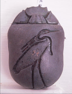
From Wiki

Heart-scarab with a decoration on the back
(Egyptian Museum, Torino)
See my book


Pyramids
In 2300 BC, Nubia was first mentioned in Old Kingdom Egyptian accounts of trade missions. From Aswan, right above the First Cataract, southern limit of Egyptian control at the time, Egyptians imported gold, incense, ebony, ivory, and exotic animals from tropical Africa through Nubia. As trade between Egypt and Nubia increased so did wealth and stability."
More http://en.wikipedia.org/wiki/Nubia

More http://en.wikipedia.org/wiki/Nubia

Makara

Museo Arte Orientale
Uttar Pradesh, II d.C.
http://it.wikipedia.org/wiki/Makara_(mitologia_indiana)
Makara (Sanskrit: मकर) is a sea-creature in Hindu mythology. It is generally depicted as half animal (in the frontal part in animal forms of elephant or crocodile or stag, or deer) and in hind part as aquatic creature, in the tail part, as a fish tail or also as seal. Sometimes, even a peacock tail is depicted.
Makara is the vahana (vehicle) of the Ganga - the goddess of river Ganges (Ganga) and the sea god Varuna. ... Makara is the astrological sign of Capricorn, one of the twelve symbols of the Zodiac. It is often portrayed protecting entryways to Hindu and Buddhist temples. Read more
http://en.wikipedia.org/wiki/Makara_(Hindu_mythology)
Le qochas dell'altopiano andino
Le "qochas" dell'altopiano andino.
In quechua, il termine "qocha" si riferisce a un piccolo lago o stagno o di origine naturale o artificiale, oppure ad un tipo di vasellame. Una "qocha" artificiale del periodo Inca si trova alla periferia di Cuzco, vicino al Rodadero, ed è la monumentale "Qocha Chincanas", un lago artificiale creato per scopi cerimoniali.
Un'antica tecnica agricola è basata sull'impiego delle qochas, sia naturali o create artificialmente, collegate tra loro da una rete di canali. Esse formano un sistema di gestione delle acque e del suolo adatto a coltivare patate e quinoa a rotazione col pascolo. Queste strutture si trovano in alcune aree pianeggianti di Perù e Bolivia, nei pressi del lago Titicaca, ad un'altitudine media di 4000 metri. Le qochas sono molto numerose nel dipartimento di Puno (Perù).
Un libro molto interessante intitolato "Agricultures Singulières", che discute alcune antiche tecniche agricole, dedica un capitolo alle qochas: secondo questo testo [1], i popoli andini hanno potuto prosperare grazie a dei sistemi agricoli, tra cui le qochas, che permettevano un utilizzo flessibile del suolo in una regione che spesso subisce periodi di siccità seguiti da inondazioni.
La forma più comune della qocha è rotonda e misura dai 30 ai 200 metri di diametro. La sua struttura concava raccoglie la pioggia tramite i suoi canali radiali e circolari (vedi figura), riducendone anche la forte evaporazione provocata dalla radiazione solare e dal vento. Adriano Forgione suggerisce che una tale struttura potrebbe permettere di misurare il tempo. In effetti, la struttura concava radiale può fornire molti punti di riferimento, per verificare il momento migliore per la semina.
Fino a cinquant'anni fa, qochas e waru-warus erano molto più utilizzati. L'introduzione dei macchinari agricoli sta portando all'abbandono o alla distruzione di queste forme tradizionali di agricoltura [2]. I waru-warus sono i "campi rialzati", un'altra tecnica agricola molto utilizzata nei pressi del Lago Titicaca. Oltre a qochas e waru-warus, vi sono altre antiche strutture agricole in Perù e Bolivia: ci sono i "bofedales", zone umide artificiali, le "andenes", che sono le colline terrazzate e i "puquios". I puquios più noti sono quelli di Nasca. Sono un sistema di gallerie sotterranee di filtraggio che forniscono l'acqua per l'irrigazione e gli usi domestici nell'area centrale di Nasca e in altre zone del Perù [3].
Il sistema di qochas ha una origine pre-incaica, come mostrato dai frammenti di ceramica trovati nelle loro vicinanze. Sebbene il sistema agricolo delle qochas sia probabilmente anteriore, di solito è associato alla cultura Pukara. Pukara era un centro importante per centinaia di anni dal 1300 aC. Tra il 250 aC e il 380 dC, divenne un importante sito religioso, densamente popolato. La società dei Pukara aveva una gestione centralizzata delle acque. Con l'ascesa di Tiwanaku, l'area è stata progressivamente abbandonata. Dopo la sua caduta, attorno al 1000 DC, l'area si ripopolò e le qochas vennero di nuovo usate. Durante i seguenti prolungati periodi di siccità, l'uso delle qochas divenne essenziale per la sopravvivenza delle popolazioni locali. Il successo di queste strutture sta nel fatto che esse sono abbastanza semplici e piccole: ognuna può essere gestita da una sola famiglia garantendone la sussistenza alimentare, mentre il terreno che la circonda è lasciato a pascolo. Oggi, molte qochas sono state abbandonate per la crescente salinità del suolo e per l'uso di macchinari agricola. La loro lunga persistenza nella storia passata dice però che il loro uso è forse quello più adatto e sostenibile dall'ambiente andino.
1. Agricultures Singulières, Mollard Eric, Walter Annie, Editors, IRD Éditions, Institute of Development Research, Paris, 2008.
2. Los camellones alrededor del lago Titicaca, Pierre Morlon, in Agricultura ancestral: camellones y albarradas. Institut français d'études andines. Quito, 2006.
3.The Puquios of Nasca, Katharina Jeanne Schreiber, Josué Lancho Rojas, Latin American Antiquity, Vol. 6, No. 3, Sep., 1995

Solo metà della struttura originaria di questa qocha in Perù si è salvata.
The Pleiades in Peru
On an ancient calendar
"Most historians agree that the Inca had a calendar based on the observation of both the Sun and the Moon, and their relationship to the stars. Names of 12 lunar months are recorded, as well as their association with festivities of the agricultural cycle... A count of this sort was described by Alexander von Humboldt for a Chibcha tribe living outside of the Inca Empire, in the mountainous region of Colombia... The smallest unit of this calendar was a numerical count of three days, which, interacting with a similar count of 10 days, formed a standard 30-day month. Every third year was made up of 13 moons, the others having 12. This formed a cycle of 37 moons, and 20 of these cycles made up a period of 60 years, which was subdivided into four parts and could be multiplied by 100. A period of 20 months is also mentioned. ...
In one account, it is said that the Inca Veracocha established a year of 12 months, each beginning with the New Moon, and that his successor, Pachacuti, finding confusion in regard to the year, built the sun towers in order to keep a check on the calendar. Since Pachacuti reigned less than a century before the conquest, it may be that the contradictions and the meagerness of information on the Inca calendar are due to the fact that the system was still in the process of being revised when the Spaniards first arrived.
Despite the uncertainties, further research has made it clear that at least at Cuzco, the capital city of the Inca, there was an official calendar of the sidereal-lunar type, based on the sidereal month of 27 1/3 days. It consisted of 328 nights (12X271/3) and began on June 8/9, coinciding with the heliacal rising (the rising just after sunset) of the Pleiades; it ended on the first Full Moon after the June solstice (the winter solstice for the Southern Hemisphere). This sidereal-lunar calendar fell short of the solar year by 37 days, which consequently were intercalated. This intercalation, and thus the place of the sidereal-lunar within the solar year, was fixed by following the cycle of the Sun as it strengthened to summer (December) solstice and weakened afterward, and by noting a similar cycle in the visibility of the Pleiades."
This is what we find at the page
http://www.lost-civilizations.net/inca-civilization-page-5.html
http://philosophyofscienceportal.blogspot.com/2008/10/pleiades-and-mythology.html
http://en.wikipedia.org/wiki/Taurus_(constellation)
http://en.wikipedia.org/wiki/Star_chart
"Most historians agree that the Inca had a calendar based on the observation of both the Sun and the Moon, and their relationship to the stars. Names of 12 lunar months are recorded, as well as their association with festivities of the agricultural cycle... A count of this sort was described by Alexander von Humboldt for a Chibcha tribe living outside of the Inca Empire, in the mountainous region of Colombia... The smallest unit of this calendar was a numerical count of three days, which, interacting with a similar count of 10 days, formed a standard 30-day month. Every third year was made up of 13 moons, the others having 12. This formed a cycle of 37 moons, and 20 of these cycles made up a period of 60 years, which was subdivided into four parts and could be multiplied by 100. A period of 20 months is also mentioned. ...
In one account, it is said that the Inca Veracocha established a year of 12 months, each beginning with the New Moon, and that his successor, Pachacuti, finding confusion in regard to the year, built the sun towers in order to keep a check on the calendar. Since Pachacuti reigned less than a century before the conquest, it may be that the contradictions and the meagerness of information on the Inca calendar are due to the fact that the system was still in the process of being revised when the Spaniards first arrived.
Despite the uncertainties, further research has made it clear that at least at Cuzco, the capital city of the Inca, there was an official calendar of the sidereal-lunar type, based on the sidereal month of 27 1/3 days. It consisted of 328 nights (12X271/3) and began on June 8/9, coinciding with the heliacal rising (the rising just after sunset) of the Pleiades; it ended on the first Full Moon after the June solstice (the winter solstice for the Southern Hemisphere). This sidereal-lunar calendar fell short of the solar year by 37 days, which consequently were intercalated. This intercalation, and thus the place of the sidereal-lunar within the solar year, was fixed by following the cycle of the Sun as it strengthened to summer (December) solstice and weakened afterward, and by noting a similar cycle in the visibility of the Pleiades."
This is what we find at the page
http://www.lost-civilizations.net/inca-civilization-page-5.html
On Pleiades see
The Pleiades: the celestial herd of ancient timekeepers by Amelia Carolina Sparavigna, (Submitted on 9 Oct 2008). In the ancient Egypt seven goddesses, represented by seven cows, composed the celestial herd that provides the nourishment to her worshippers. This herd is observed in the sky as a group of stars, the Pleiades, close to Aldebaran, the main star in the Taurus constellation. For many ancient populations, Pleiades were relevant stars and their rising was marked as a special time of the year. In this paper, we will discuss the presence of these stars in ancient cultures. Moreover, we will report some results of archeoastronomy on the role for timekeeping of these stars, results which show that for hunter-gatherers at Palaeolithic times, they were linked to the seasonal cycles of aurochs.http://philosophyofscienceportal.blogspot.com/2008/10/pleiades-and-mythology.html
http://en.wikipedia.org/wiki/Taurus_(constellation)
http://en.wikipedia.org/wiki/Star_chart
Subscribe to:
Posts (Atom)