"Today, hundreds of foreign and Egyptian journalists along with photographers, cameramen and TV presenters flocked to the Giza Plateau, where Minister of State for Antiquities Zahi Hawass, Chargé d’Affaires at the Japanese Embassy to Egypt Masami Kinefuchi, and the chief executive representative of the Nitori Holding Company, Akio Nitori, unveiled King Khufu’s second solar boat. This boat was first discovered in 1954 by Egyptian architect and archaeologist Kamal El-Malakh with fellow archaeologist Zaki Nour during routine cleaning at the southern side of Khufu’s Great Pyramid. The first pit was found under a roof of 41 limestone slabs. Removing one of these slabs, a cedar boat, completely dismantled but arranged in the semblance of its finished form, was found along with layers of mats, ropes, instruments made of flint and some small pieces of white plaster with 12 oars, 58 poles, three cylindrical columns and five doors."
Khufu’s second solar boat revealed - Ancient Egypt - Heritage - Ahram Online
Thursday, 23 June 2011
Wednesday, 22 June 2011
Four actors

A group of four actors
Tang Dinasty, first half of the 8th century AD
Museo Arte Orientale, Torino

Padmapani

Padmapani
Gandhara, II-III secolo d.C.
Il Bodhisattva Padmapani siede su un alto trono con il piede sinistro posato a terra e la gamba destra piegata a appoggiata sul ginocchio opposto. L’alto seggio su cui Padmapani è seduto ha una spessa base su cui si appoggiano i sandali (infradito!). Il Bodhisattva indossa paridhana e uttariya. Porta un turbante a fascia, grandi orecchini a testa di leone, collane e un cordone con piccoli involucri porta-preghiere, portato di traverso dalla spalla sinistra al fianco destro. Padmapani tiene nella mano sinistra un grosso bocciolo di fiore di loto, mentre l’altra, mancante, era rivolta verso la testa.
Museo Arte Orientale, Torino
Il funzionario militare
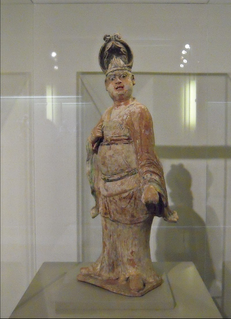
Funzionario militare
Dinastia Tang, VIII secolo D.C.
Terracotta rossa, ingobbio bianco, pigmenti e oro
Military official
Tang Dinasty 8th centry A.D.
Red earthenware with white engobe, pigments and gold

Museo Arte Orientale, Torino
Dinastia Tang, VIII secolo D.C.
Terracotta rossa, ingobbio bianco, pigmenti e oro
Military official
Tang Dinasty 8th centry A.D.
Red earthenware with white engobe, pigments and gold

Museo Arte Orientale, Torino
Geoglyphs in Bolivia

The image shows the "raised fields" near the Titicaca Lake, in Bolivia.
Note the "snake": eye, tongue and teeth.
This image, obtained after processing a Google Maps image, shows the network of waru-warus, that is, of the "raised fields" - earthworks separated by canals - near Tiwanaku. This is an ancient agricultural technique used by Andean people starting from the first millennium BC. Each raised field is approximately 10 meters large and more than one hundred long.
More on waru-waru
Andenes in peru

Andenes are an ancient method to cultivate the Andean highlands.
Here an image from Google Maps.
Ringed hills
A beautiful collection of images from Google Maps.
http://www.atlantisbolivia.org/ringedhills.htm
Very interesting the top of the hill with concentric rings!
"Many of the hilltops on the Bolivian altiplano have at some time been surrounded by concentric ringed walls and/or irrigation channels and many of these hilltops in turn seem to have suffered from earthquake damage. Closer study suggests that many hilltops originally had concentric ringed irrigation canals, but in many zones these appear to have been destroyed by earthquakes and later generations have reoccupied the land and built walls alongside the former irrigation ditches."
I have searched the "ringed feature south of volcan Quemado". Here it is after processing.


http://www.atlantisbolivia.org/ringedhills.htm
Very interesting the top of the hill with concentric rings!
"Many of the hilltops on the Bolivian altiplano have at some time been surrounded by concentric ringed walls and/or irrigation channels and many of these hilltops in turn seem to have suffered from earthquake damage. Closer study suggests that many hilltops originally had concentric ringed irrigation canals, but in many zones these appear to have been destroyed by earthquakes and later generations have reoccupied the land and built walls alongside the former irrigation ditches."
I have searched the "ringed feature south of volcan Quemado". Here it is after processing.

Another ringed structure

Images obtained by Google Maps
Alpaca
In the "The Continuum encyclopedia of animal symbolism in art", by Hope B. Werness, we can find a very interesting discussion on Alpaca.

Waru-warus

This image, obtained after processing a Google Maps image, shows the network of waru-warus, that is, of the "raised fields" - earthworks separated by canals - near the Titicaca Lake (Huata, Puno, Peru). This is an ancient agricultural technique used by Andean people starting from the first millennium BC. Note that the structure of the network is created after a careful planning.
Each raised field is approximately 10 meters large and more than one hundred long.
arXiv:1009.4602 [pdf] Geoglyphs of Titicaca as an ancient example of graphic design, Amelia Carolina Sparavigna
arXiv:1009.2231 [pdf] Symbolic landforms created by ancient earthworks near Lake Titicaca, Amelia Carolina Sparavigna
Radial structures at Rodadero
As discussed in some previous posts on "qochas", these structures had and have an agricultural function. Some qochas had a ceremonial use too. At Rodadero (Cusco) we find the huge Qocha Chincanas.
Near the parking of this archaeological site, where it is placed the statue of the White Christ, the satellite imagery (Google Maps) shows two radial/circular structures as those used for agricultural purposed near Titicaca lake.

Near the parking of this archaeological site, where it is placed the statue of the White Christ, the satellite imagery (Google Maps) shows two radial/circular structures as those used for agricultural purposed near Titicaca lake.

Near Qenko and Rodadero
One of the beautiful examples of the Incaic culture in the Cusco region are the ruins of Qenko, located approximately 6 kilometers from the capital of the area, Cusco. Qenko is near the Rodadero, a giant rock hill with numerous stairwells and benches carved into the stone. The hills near Qenko and Rodadero are used as cropfields. During this weekend I was studying qochas (lakes, ponds) and searching for ceremonial qochas in Peru, when I saw by means of Google Maps this hill. After image processing to enhance details, it seems that this hill possesses many concentric structures, as a qocha. May be it is another ceremonial qochas near Cusco.

Geoglyphs of Titicaca
Geoglyphs of Titicaca
 28 p. Book Geoglyphs Titicaca Sparavigna
Images of geoglyphs near Titicaca Lake. The ancient artificial landscape
with geoglyphs is an important example of an engineering graphic design
for an age and place where no written documents existed. Geoglyphs
are created by a network of earthworks, which constitute the remains
of an extensive ancient agricultural system. It can be seen by means
of the Google satellite imagery on the Peruvian region near the Titicaca Lake.
Public Category: Research Reads: 2657 Published: 10 / 09 / 2010 Share Add to Collections
Public Category: Research Reads: 2657 Published: 10 / 09 / 2010 Share Add to Collections
Landforms of Titicaca: Near Sillustani
 18 p. Landforms of Titicaca: Near Sillustani, Book by A.C. Sparavigna
Terraced hills, a network of earthworks, sometimes creating geoglyphs,
and ancient ruins are the structures we can observe with the satellites
imagery of Google Maps. After the previous publications on the
earthworks and geoglyphs , let us survey specific area with more
details. Here we show satellite imagery, enhanced with freely
available image processing software, of the area near Sillustani,
the peninsula of the Laguna Umayo, in Puno region of Peru.
Besides Sillustani, interesting places are the
Mesa Isla and Atuncalla.
Public Category: Research Reads: 286 Published: 10 / 27 / 2010
Public Category: Research Reads: 286 Published: 10 / 27 / 2010
Landforms of Titicaca: Amazing Land
 18 p. Landforms Titicaca Amazing Land by AC Sparavigna
The areas of Huata, Coata and Paucarcolla, near the Titicaca Lake,
are covered by amazing drawings. For these regions, Google Maps
has enough high resolution to have a detailed survey.
In the book, the reader can see a show of images obtained
by enhancing the satellite imagery.
Each image has coordinates and scale.
Public Category: Research Reads: 207 Published: 10 / 28 / 2010
Share Add to Collections
A snake

Image from Google Maps after processing to enhance details.
Near the Titicaca Lake, Peru.
It seems a snake, the pond as its eye and a bifid tongue.
To see the forked tongue it is necessary a zoom on the head and a filtering with wavelets to enhance the details.


More on waru-waru
arXiv:1009.4602 [pdf] Geoglyphs of Titicaca as an ancient example of graphic design,
arXiv:1009.2231 [pdf] Symbolic landforms created by ancient earthworks near Lake Titicaca,
Subscribe to:
Posts (Atom)