Suggested reading
Piero Barale, UN REBUS AI PIEDI DEL MONVISO RIFERIMENTI ASTRONOMICI
EMERSI DA ALCUNE INCISIONI RUPESTRI DELLE ALPI SUDOCCIDENTALI
The Po valley that, detaching from the Monviso, is the most important way to
get to this impressive mountain, had to favour different religious events as shown
by the still existing rock-engraving symbolizing the ancient people who pray.
These ancient cultural events have shown interesting astronomical
characteristics proving how the correlation between rock-engraving and the sky
observation during special periods of the year could be closed.
From the ideal centre from where the rock-engravings start, it seems it could be
possible to fix with great precision the changing of the seasons.
Furthermore, the users of this supposed “natural calendar” could get
information about the moon position during particular periods of its cycle;
situation that has always aroused great interest.
http://www.brera.unimi.it/sisfa/atti/1997/Barale.pdf
"La valle Po, già frequentata nel Neolitico20 dai “cercatori della pietra verde” -
(Pirosseni-Giadeite) materiale litico di elevata durezza che veniva estratto nei
depositi alluvionali della valle-, vedrà forse apparire le prime rappresentazioni
rupestri con la fine dell’età del Rame - inizio età del Bronzo. Ma con molta probabilità
il periodo di massimo sviluppo e popolarità del fenomeno si avrà solo
nell’età del Ferro. "
see also
http://stretchingtheboundaries.blogspot.it/2013/03/monte-viso.html
Saturday, 30 March 2013
"Monte Viso is the location of a neolithic jadeite quarry, at an elevation of 2000 to 2400 metres. Its productivity peaked around 5000 BC. The jadeite was used to make cult axes, which are found all over western Europe." From Wiki
Geheimnisvolle Kult-Beile: Statussymbole der Steinzeit, Von Almut Bick
Sie sind ein Mysterium, eines der größten Rätsel aus der Zeit der Jäger und Sammler: Steinklingen aus kostbarstem Jadeit. Wozu dienten diese Äxte, die Archäologen in halb Europa gefunden haben? Forscher sind dem Geheimnis nun dicht auf der Spur ...Über sechstausend Jahre ist es her, dass die steinzeitlichen Bergleute mit dem äußerst seltenen Jadeit heimkehrten. Hoch oben, jenseits der Schneegrenze des Monte Viso in den italienischen Alpen, betrieben sie einen regelrechten Steinbruch für das grüne Mineral. ...
http://www.spiegel.de/wissenschaft/mensch/geheimnisvolle-kult-beile-statussymbole-der-steinzeit-a-477917.html
See also:
Zwischen Atlantik und Schwarzem Meer , Die großen Beile aus alpinem Jadeit im 5. und 4.Jt. v. Chr
by Serge Cassen
http://www.academia.edu/1954923/Zwischen_Atlantik_und_Schwarzem_Meer_Die_grossen_Beile_aus_alpinem_Jadeit_im_5._und_4.Jt._v.Chr
Zu den Jadeit-Quellen am Monte Viso
by Rengert Elburg
http://www.academia.edu/3119319/Zu_den_Jadeit-Quellen_am_Monte_Viso
Geheimnisvolle Kult-Beile: Statussymbole der Steinzeit, Von Almut Bick
Sie sind ein Mysterium, eines der größten Rätsel aus der Zeit der Jäger und Sammler: Steinklingen aus kostbarstem Jadeit. Wozu dienten diese Äxte, die Archäologen in halb Europa gefunden haben? Forscher sind dem Geheimnis nun dicht auf der Spur ...Über sechstausend Jahre ist es her, dass die steinzeitlichen Bergleute mit dem äußerst seltenen Jadeit heimkehrten. Hoch oben, jenseits der Schneegrenze des Monte Viso in den italienischen Alpen, betrieben sie einen regelrechten Steinbruch für das grüne Mineral. ...
http://www.spiegel.de/wissenschaft/mensch/geheimnisvolle-kult-beile-statussymbole-der-steinzeit-a-477917.html
See also:
Zwischen Atlantik und Schwarzem Meer , Die großen Beile aus alpinem Jadeit im 5. und 4.Jt. v. Chr
by Serge Cassen
http://www.academia.edu/1954923/Zwischen_Atlantik_und_Schwarzem_Meer_Die_grossen_Beile_aus_alpinem_Jadeit_im_5._und_4.Jt._v.Chr
Zu den Jadeit-Quellen am Monte Viso
by Rengert Elburg
http://www.academia.edu/3119319/Zu_den_Jadeit-Quellen_am_Monte_Viso

Sunday, 3 March 2013

Thursday, 21 February 2013
Neolithic mounds of Tassili and Amguid
Today I read this beautiful article, entitled, ALGERIA, ”TASSILI n’AJJER”, Viaggio effettuato dal 01 al 10 Novembre 2001, By Davide Bergami e Antonella Bergonzoni, Posted Saturday, November 19, 2005 on
http://www.sahara.it/bm/saharaThree/viaggi/resoconti/algeria-tassili-najjer.shtml

More about this at
http://www.sahara.it/bm/saharaThree/viaggi/resoconti/algeria-tassili-najjer.shtml
Among the images the authors are showing of the travel there is the picture of a Neolithic mound, a "key-hole" tomb. Here a partial reproduction of their image

Algeria was populated since 10,000 BCE, as shown by several archaeological sites located in the Tassili National Park. Very important are there the engravings and cave paintings, dated between 8000 and 4000 BCE, where people of Neolithic age depicted animals such as elephants and hippopotami, showing that once the climate was rather different and far wetter than it is today.
The Tassili n'Ajjer is a vast plateau in south-east of Algeria. In Berber its name means the Plateau of the Rivers. This plateau is composed mainly of sandstone. Because of the water-holding properties of the sandstone, the vegetation here is somewhat richer than in the surrounding desert. In fact, the name "Plateau of the rivers" seems to echo that period of time, known as the Neolithic Subpluvial or Holocene Wet Phase, when the climate of Maghreb was wet. It was a period preceded and followed by drier periods, the most recent of some wet climatic conditions of the Sahara, named "Green Sahara", during which the region supported a rich vegetation, animals and humans.
The Tassili n'Ajjer is a vast plateau in south-east of Algeria. In Berber its name means the Plateau of the Rivers. This plateau is composed mainly of sandstone. Because of the water-holding properties of the sandstone, the vegetation here is somewhat richer than in the surrounding desert. In fact, the name "Plateau of the rivers" seems to echo that period of time, known as the Neolithic Subpluvial or Holocene Wet Phase, when the climate of Maghreb was wet. It was a period preceded and followed by drier periods, the most recent of some wet climatic conditions of the Sahara, named "Green Sahara", during which the region supported a rich vegetation, animals and humans.
Some Neolithic mounds, built by the ancient populations that lived in what once was a "Green Sahara", are visible in the satellite images of Google Maps. In particular, due to a high enough resolution, we can see some of the mounds of the regions of Tassili and Amguid in Algeria.
More about this at
Neolithic mounds of Tassili and Amguid in the satellite Google Maps
Monday, 10 December 2012
Dimensions for making a replica Roman dodecahedron (1)
Let us suppose somebody wants to make a replica of a Roman dodecahedron,
here a recipe. Consider the following image
here a recipe. Consider the following image

Centered at the center of each face, draw a circle, which will be a hole. These circles usually have different diameters. Print and cut the image.
If you want some figures, you can, for instance use the article at the following link:
http://www.scribd.com/doc/116123429/The-Roman-Dodecahedron-of-Kadath
Here I am reproducing a table.
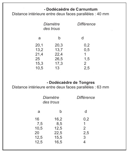
Here we have not the exact potions of the holes, but we have the diameters of hole on the opposite faces.
According to the image of the dodecahedron, 1 is opposite 12, 2 opposite 11, 3 opposite 10, etc.

Tuesday, 16 October 2012
"Carved stone balls from Scotland are an enigmatic class of objects. They date to the late Neolithic or early Bronze Age, between 3200 and 1500 BC, and are made of various stones ranging from sandstone to granite. They ... are decorated with carved evenly-spaced patterns of circular bosses or knobs around the surface of the sphere. The designs vary with the majority being based around a series of six bosses, but the number of bosses varies from 3-160."
More at http://www.ashmolean.org/ash/britarch/highlights/stone-balls.html

More at http://www.ashmolean.org/ash/britarch/highlights/stone-balls.html

Saturday, 22 September 2012
When America discovered Europe
A very remarkable book this one
The American discovery of Europe, By Jack D. Forbes
Let me suggest the reading of it. To stimulate the curiosity, here some small abstracts
The American discovery of Europe, By Jack D. Forbes
Let me suggest the reading of it. To stimulate the curiosity, here some small abstracts
What is Cornelius Nepos telling? And Pliny?


Wednesday, 15 August 2012
Empresa destruye patrimonio cultural
Empresa destruye patrimonio cultural
"El observatorio más antiguo de América, es afectado por trabajos de empresa autorizada por el INC. Desconocen informes que dan cuenta de restos arqueológicos alrededor de área patrimonial."
"El observatorio más antiguo de América, es afectado por trabajos de empresa autorizada por el INC. Desconocen informes que dan cuenta de restos arqueológicos alrededor de área patrimonial."
Ancient solar observatories: Syrian desert
The Syrian desert is covered by ancient stone structures created during Neolithic times, as I discussed in the paper, Stone circles on the harraat of Syrian desert, published at http://arxiv.org/abs/1106.4665
Some of these stone structures are circular, with radial lines of stones. These circles have been also compared with Stonehenge. Therefore, we can ask ourselves, are these solar observatories too, as Stonehenge is.
The answer is probably so, see my paper at http://arxiv.org/abs/1208.2591
I used a software for the solar energy applications to see the direction of sun on sunrise and sunset of solstice. It seems that there is a good agreement. Therefore, the Syrian stone circles are probably the Stonehenges of Middle East.
 This is one of the stone structure of Syrian Desert. The image shows directions of sun during the day. “The lines on the drawing show the direction and height (altitude) of the sun throughout the day. Thicker and shorter lines mean the sun is higher in the sky. Longer and thinner lines mean the sun is closer to the horizon”, according to Sollumis.com http://www.sollumis.com/. On the left, the site as it appears in the Google Maps. In the middle, the direction of the sun on the summer solstice, choosing the center of the circle for observation. We see that, at sunrise, the sun is passing near the dot. At the sunset the direction is that of a line. In the image on the right, we see the direction of the sun on winter solstice. At sunrise, the lines is passing between dots. The sunset has the direction of a radius (images have been obtained from original provided by Google Maps and sollumis.com).

Some of these stone structures are circular, with radial lines of stones. These circles have been also compared with Stonehenge. Therefore, we can ask ourselves, are these solar observatories too, as Stonehenge is.
The answer is probably so, see my paper at http://arxiv.org/abs/1208.2591
I used a software for the solar energy applications to see the direction of sun on sunrise and sunset of solstice. It seems that there is a good agreement. Therefore, the Syrian stone circles are probably the Stonehenges of Middle East.
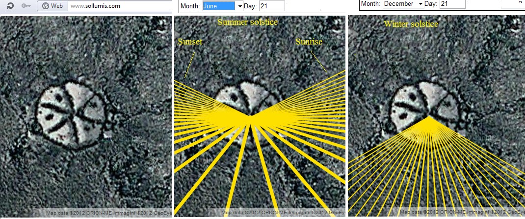

Circles and lines!
Alignemnt at the sunrise on the winter solstice
At the site http://www.dp-news.com/en/detail.aspx?articleid=97188
it is told that "He (David Kennedy) explains that they come in a huge variety of forms, some being ‘kites’, structures that funnelled animals, some being seemingly random meandering lines of stone and others being rectangular. None are believed to be aligned with the stars, which has added to the mystery surrounding their purpose." Well, in my opinion it is not so.
Alignemnt at the sunrise on the winter solstice
At the site http://www.dp-news.com/en/detail.aspx?articleid=97188
it is told that "He (David Kennedy) explains that they come in a huge variety of forms, some being ‘kites’, structures that funnelled animals, some being seemingly random meandering lines of stone and others being rectangular. None are believed to be aligned with the stars, which has added to the mystery surrounding their purpose." Well, in my opinion it is not so.
Tuesday, 24 July 2012
Roman jewelry in Japan
TOKYO —"Glass jewelry believed to have been made by Roman craftsmen has been found in an ancient tomb in Japan, researchers said Friday, in a sign the empire’s influence may have reached the edge of Asia."
http://www.japantoday.com/category/national/view/roman-jewelry-found-in-ancient-tomb-near-kyoto
http://www.japantoday.com/category/national/view/roman-jewelry-found-in-ancient-tomb-near-kyoto
20,000 years old pottery in a Chinese cave
"BEIJING (AP) - Pottery fragments found in a south China cave have been confirmed to be 20,000 years old, making them the oldest known pottery in the world, archaeologists say."
New Jersey Herald - Pottery 20,000 years old found in a Chinese cave
New Jersey Herald - Pottery 20,000 years old found in a Chinese cave
Small oscillations ...
"Researchers Terry Hunt and Carl Lipo test a new theory that suggests how ancient Easter Islanders may have used ropes to “walk” the moai to their platforms. Mystery of Easter Island"
Aléria dodecahedron

This image is adapted from YouTube http://www.youtube.com/watch?v=x_2OrVzC46Y
It is showing a rock crystal dodecahedron found at Aléria Corisca
Tuesday, 19 June 2012
Arles, Turin and Caesar
The heart of the ancient history of Arles, this is what is on show at the Louvre Museum of Paris, until 25 June 2012. The Museum is hosting an exhibition of spectacular Roman pieces recovered from the bottom of the Rhone! From March 9 to June 25, 2012, the Louvre Museum in Paris
On exhibition fifty of the most spectacular artifacts unearthed by archaeologists: columns and capitals, fragments of statues and reliefs, Roman jewelery, lamps, vases ... These pieces are coming from the museum of Arles, and other pieces from Avignon, Vienne and Turin.
Among the pieces from Turin, you can admire Julius Caesar's bust, unearthed in 1825, long considered unique, until the discovery in 2007 in Arles of another bust of the Roman politician. At the Louvre, these sculptures will be presented for the first time side by side.
http://www.france.fr/it/arti-e-cultura/evenement/arles-gli-scavi-del-rodano-un-fiume-memoria


On exhibition fifty of the most spectacular artifacts unearthed by archaeologists: columns and capitals, fragments of statues and reliefs, Roman jewelery, lamps, vases ... These pieces are coming from the museum of Arles, and other pieces from Avignon, Vienne and Turin.
Among the pieces from Turin, you can admire Julius Caesar's bust, unearthed in 1825, long considered unique, until the discovery in 2007 in Arles of another bust of the Roman politician. At the Louvre, these sculptures will be presented for the first time side by side.
http://www.france.fr/it/arti-e-cultura/evenement/arles-gli-scavi-del-rodano-un-fiume-memoria



Friday, 18 May 2012
An ancient rangefinder (Roman Dodecahedron)
According to Wikipedia, "a rangefinder is a device that measures distance from the observer to a target, for the purposes of surveying, determining focus in photography, or accurately aiming a weapon. Some devices use active methods to measure (such as sonar, laser, or radar); others measure distance using trigonometry (stadiametric rangefinders and parallax, or coincidence rangefinders). These methodologies use a set of known information, usually distances or target sizes, to make the measurement, and have been in regular use since the 18th century".
It could be surprising, but probably the Roman Army had a rangefinder. It was the Roman Dodecahedron (I have already discussed it in some posts and papers: on arXiv, where I am explaining how it can be used for measuring distance as a rangefinder, http://arxiv.org/abs/1204.6497 , and in Italiano ahttp://porto.polito.it/2497004/ ).
For me, those dodecahedrons having a structure with holes of different sizes, are military instruments to evaluate distances for ballistics. It is simple to use. Of course, later, during the Middle Age, different instruments had been developed for surveying: the dodecahedron was of the Roman Army, and, probably, its use lost after the collpase of the Empire. See also "Ancient and Modern Rangefinders", arXiv, http://arxiv.org/abs/1205.2078

It could be surprising, but probably the Roman Army had a rangefinder. It was the Roman Dodecahedron (I have already discussed it in some posts and papers: on arXiv, where I am explaining how it can be used for measuring distance as a rangefinder, http://arxiv.org/abs/1204.6497 , and in Italiano ahttp://porto.polito.it/2497004/ ).
For me, those dodecahedrons having a structure with holes of different sizes, are military instruments to evaluate distances for ballistics. It is simple to use. Of course, later, during the Middle Age, different instruments had been developed for surveying: the dodecahedron was of the Roman Army, and, probably, its use lost after the collpase of the Empire. See also "Ancient and Modern Rangefinders", arXiv, http://arxiv.org/abs/1205.2078

Subscribe to:
Posts (Atom)